DACF Home → Bureaus & Programs → Maine Geological Survey → Maps, Publications and Online Data → Coastal Sand Dune Geology Maps → Coastal Sand Dune Systems
Coastal Sand Dune Systems
Coastal Hazards
Maine's stretches of sandy beach present an attractive place to live. The beauty of living on the coast, however, comes with built-in risks. In Figure 1, storm waves pound the beach at the base of two houses built on the frontal dune. In subsequent years, storms destroyed both of these houses. Erosion in this area has exceeded 80 feet since 1950 and is expected to continue. It is important to remember that the interplay of winds, waves, tides, and currents continually reshapes Maine's beach environments. Storm surges, sea-level rise, and inlet migration make coastal erosion a continuing process. Over time, the location and shape of today's beaches and dunes will continue to change. Although natural, this change can create a hazard to some coastal development.
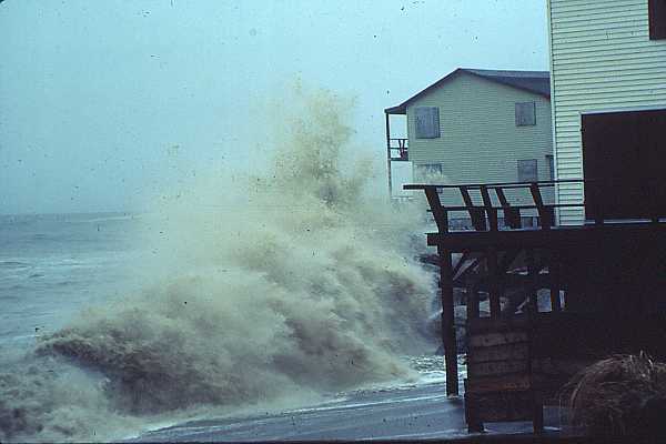 Figure 1
Coastal Sand Dunes
Sand dune systems are sand and gravel deposits within a marine beach system, including, but not limited to beach berms, frontal dunes, dune ridges, back dunes and other sand and gravel areas deposited by wave or wind action (Figure 2). Coastal sand dunes may extend into the coastal wetlands. The dune system includes areas which have been artificially covered by structures, lawns, roads, and fill. Sand dune systems also include all vegetation which is native to and occurring in the system. Building in Maine's sand dune system is regulated by the Coastal Sand Dune Rules.
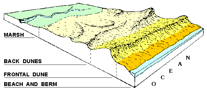
Figure 2
Coastal Sand Dune Rules
The Maine Natural Resources Protection Act (NRPA: Title 38 M.R.S.A., Chapter 3, Section 480D, 2000) requires that new coastal development will not unreasonably (1) interfere with the natural supply or movement of sand within or to the sand dune system; (2) increase the erosion hazard to the sand dune system; (3) cause or increase the flooding of the dunes or adjacent properties; (4) interfere with the natural flow of any surface or subsurface waters; (5) inhibit the natural transfer of soil from the terrestrial to marine environments; (6) harm any significant wildlife habitat, threatened or endangered plant habitat, travel corridor, freshwater, estuarine or marine life; or (7) interfere with existing scenic, aesthetic, recreational, or navigational uses.
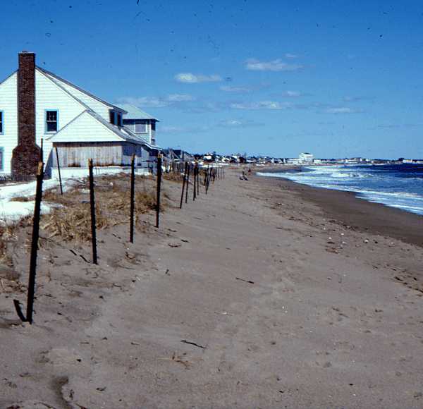
Figure 3
The Coastal Sand Dune Rules clarify the criteria for obtaining a permit under NRPA (in regard to coastal sand dune systems). The rules outline classes of projects which are exempt from the requirement of obtaining a permit. For all other projects, the rules outline standards which must be met to satisfy the statutory criteria.
Using Coastal Sand Dune Photos
Permits are usually required for building projects located in Maine's coastal sand dune system. Such projects are described in the Coastal Sand Dune Rules of the Maine Department of Environmental Protection. The rules are based on the location of the project within the sand dune system.
These beach and dune geology photos delineate the dunes, beaches, channels, and wetlands that make up and border coastal sand dune environments. The boundaries shown on the photos provide guidance for interpreting the geology of the dune system with respect to the Coastal Sand Dune Rules. The location of the boundaries of the frontal dune (D1) and the back dune (D2) are especially important in the permit process (view the photo explanation (pdf)).
Geologic environments delineated on these photos are based on 1986 aerial photographs and field work by the Maine Geological Survey. These photos are considered to be the best information available for showing existing conditions and location of frontal dunes and back dunes, unless an on-site survey indicates otherwise. Geologic boundary accuracy is � 3.5 meters (12 feet).
These photos may be revised as natural changes occur. Some coastal sand dunes have not been mapped. In these areas, refer to the definition of a sand dune system in the Sand Dune Rules to determine the applicability of the law. Coastal Marine Geologic Environments maps for the rest of the Maine coast are available from the Maine Geological Survey for areas not covered in this detailed photo series.
Sources and Acknowledgments
Geologic interpretation by Stephen M. Dickson based on field work and 1986 aerial photographs at a scale of 1:4,800. Information transferred to the photo bases by Jason N. Weist. Original interpretation of the geologic boundaries was carried out in 1990 to produce the Coastal Sand Dune Maps published by the Maine Geological Survey. The Coastal Sand Dune maps were peer reviewed by four coastal geologists and through two public workshops. Funding for the original mapping project was provided by the Maine Geological Survey, the Department of Environmental Protection and, in part, by the Maine Coastal Program with funds from the U.S. Department of Commerce, Office of Ocean and Coastal Resource Management as provided by the Coastal Zone Management Act of 1972, as amended.
How to Obtain Printed Copies
Printed copies of this photo and photos of other beaches may be purchased from the Maine Geological Survey, 93 State House Station, Augusta, ME 04333-0022 (207-287-2801).
E-mail: mgs@maine.gov.
Additional Sources of Information
Beach Processes
Carter, R.W.G., 1988, Coastal environments: Academic Press, San Diego, California, 617 p.
Kaufman, W., and Pilkey, O., 1979, The beaches are moving: Anchor Press, Garden City, New York, 326 p.
Kelley, J.T., Kelley, A.R., and Pilkey, O.H., Sr., 1989, Living with the coast of Maine: Duke University Press, Durham, North Carolina, 174 p., (Available from the Maine Geological Survey).
Komar, P.D., 1998, Beach processes and sedimentation (2nd edition): Prentice-Hall, Upper Saddle River, New Jersey, 544 p.
National Research Council, 1995, Beach nourishment and protection: National Academy Press, Washington, D.C., 334 p.
Pugh, D.T., Tides, surges, and mean sea-level: John Wiley & Sons, New York, New York, 472 p.
Coastal Construction and Hazards
Kelley, J.T., Kelley, A.R., and Pilkey, O.H., Sr., 1989, Living with the coast of Maine: Duke University Press, Durham, North Carolina, 174 p., (Available from the Maine Geological Survey).
Federal Emergency Management Agency, 2000, Coastal construction manual (3rd edition): Federal Emergency Management Agency (FEMA), 3 volumes.
Coastal Sand Dune Rules and Maine Natural Resources Protection Act
Department of Environmental Protection, 1993, Coastal Sand Dune Rules - Chapter 355: Maine Department of Environmental Protection, Bureau of Land and Water Quality, 17 State House Station, Augusta, ME 04333-0017, 21 p.
Department of Environmental Protection, 2000, Natural Resources Protection Act (38 MRSA, Chap. 3, Secs. 480-A to 480-Z): Maine Department of Environmental Protection, Bureau of Land and Water Quality, 17 State House Station, Augusta, ME 04333-0017, 35 p.
Sea-Level Rise and Coastal Flooding
Anticipatory planning for sea-level rise along the coast of Maine, 1994: Maine State Planning Office (38 State House Station, Augusta, Maine, 04333). Now available from U.S. Environmental Protection Agency.
Lyles, S.D., Hickman, L.E., Jr., Debaugh, H.A., Jr., 1988, Sea Level Variations for the United States, 1855-1986, U.S. Department of Commerce, Rockville, Maryland, 182 p.
State Planning Office, 2000, Maine floodplain management handbook: Maine State Planning Office, Augusta, Maine.
Last updated on Janaury 26, 2015