Home → Air Quality → Monitoring and Reporting → Monitoring Sites Map
Maine's Air Monitoring Sites
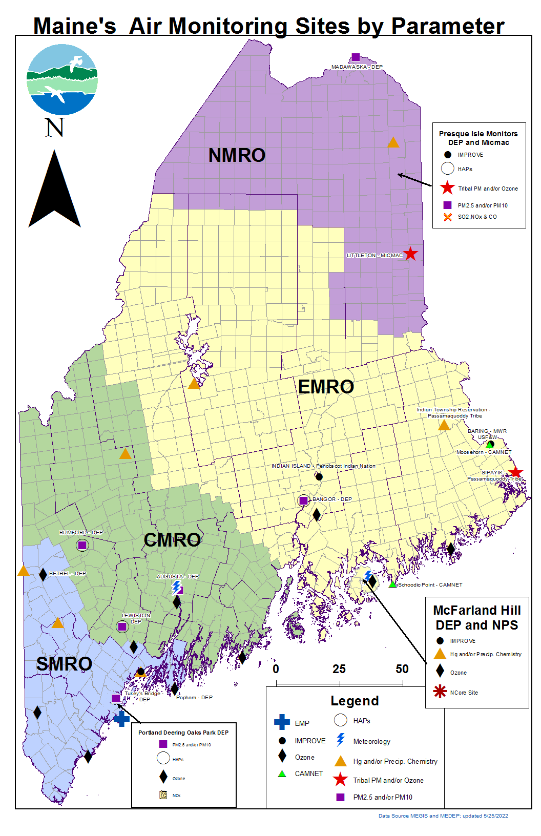
Monitor Map Legend Explained
Regional Offices – The Maine Department of Environmental Protection (Maine DEP) maintains four regional offices around the state. Each office is responsible for air quality monitoring in their respective region, displayed on the map as: Northern Maine Regional Office (NMRO) - in Presque Isle, Eastern Maine Regional Office (EMRO) - in Bangor, Central Maine Regional Office (CMRO) - in Augusta and Southern Maine Regional Office (SMRO) - in Portland.
Monitoring Organizations – While Maine DEP carries out the bulk of air quality monitoring within the state, air quality data is also collected by several other organizations. The other organizations conducting air quality monitoring include: the Aroostook Band of Micmacs, the Penobscot Indian Nation, two bands of the Passamaquoddy Tribe, the National Park Service, the U.S. Fish & Wildlife, the Environmental Protection Agency (through their CASTNet program) and the United States Geological Survey.
Monitoring Site Objectives – Some sites collect one type of data only, such as ozone or meteorology (wind direction, wind speed, etc.), where others will have multiple monitoring objectives (which has the added benefit of reducing overall costs). That is why several symbols will be stacked on the map. Many such sites will also qualify as part of one or more nationwide networks. These networks specify the parameters of data to be collected and quality assurance methods to be used. Among these nationwide networks are:
- IMPROVE – Interagency Monitoring of Protected Visual Environments sites collect data on particulate matter (PM) fractions varying in particle size (e.g. 2.5 and 10 microns in diameter) and a suite of elements that form compounds which contribute to Regional Haze and visibility impairment. IMPROVE was enacted by EPA in 1985 and is governed by a steering committee composed of representatives from Federal and regional-state organizations. It is intended to be a long-term monitoring program that has established the initial status of visibility conditions and continues to track trends in visibility and determine causal mechanisms for the visibility impairment in the National Parks and Wilderness areas.
- NCore – National Core monitoring is a multi-pollutant network that includes measurement systems for PM, lead, carbon monoxide, nitrogen oxides, sulfur dioxide, ozone and meteorology. NCore was established in 2006 and formally implemented in 2011. It is expected that each state will have at least one NCore site. The multi-pollutant monitoring approach is expected to benefit health assessments, emissions strategy development and future monitoring efforts. With such a robust suite of collocated measurements NCore sites will better characterize the numerous chemical and physical interactions between pollutants for researchers and policymakers.
- EMP – Enhanced Monitoring Program collecting photochemical compounds, ozone, targeted reactive nitrogen and volatile organic compounds (NOy and VOCs, respectively) and meteorological parameters (wind direction/speed, temperature, barometric pressure, relative humidity and solar radiation). Data from EMP sites will provide a comprehensive air quality database for ozone and its precursors. The intent is to better characterize the nature and extent of the ozone problem which will inform attainment/nonattainment decisions by evaluating, tracking the progress of, and, if necessary, refining control strategies for ozone. The data will be particularly useful to States in ensuring implementation of the most cost-effective regulatory controls.
- NADP – National Atmospheric Deposition Program measures mercury wet deposition and/or various chemistry parameters of precipitation important in the assessment and tracking of 'acid rain'. These sites provide data to the NADP which serves scientific and educational needs and supports informed decisions on air quality issues related to precipitation chemistry. NADP was established in 1977 to address the problem of atmospheric deposition and its effects on agriculture crops, forests, rangelands, surface waters, and other natural and cultural resources. It is a cooperative effort between many different groups including: federal, state, tribal and local government agencies, educational institutions, private companies and non-governmental agencies. Since its inception, NADP has grown to include five monitoring networks:
- National Trends Network (NTN)
- Atmospheric Integrated Research Monitoring Network (AIRMoN)
- Mercury Deposition Network (MDN)
- Atmospheric Mercury Network (AMNet)
- Ammonia Monitoring Network (AMON)
- CASTNet – EPA's Clean Air Status and Trends Network has several sites in Maine which measure ozone and dry deposition components. CASTNet sites compliment the NADP's National Trends Network. The intent is to assess trends in acidic deposition due to emission reduction programs, such as the Acid Rain Program, NOx Budget Trading Program and the Clean Air Interstate Rule. CASTNet provides additional data to estimate long-term temporal and spatial trends in total deposition (wet and dry) as well as ecosystem health.
- Camnet – A project of the Northeast States Coordinated Air Use Management (NESCAUM), Camnet sites produce live pictures of scenic urban and rural vistas in the Northeast and their location's corresponding air quality conditions, which can be viewed online at http://www.hazecam.net/allsites.aspx The purpose of Camnet is to raise public awareness about the effects of air pollution on visibility. Camnet pictures are updated every 15 minutes. Near-real time air pollution and meteorological data are provided hourly to help distinguish natural from man-made causes of poor visibility, and to provide health-relevant data to the public on current air pollution levels.
Additionally, there are various pollutant symbols/abbreviations used on the map. Among them:
- HAPs – Hazardous Air Pollutants, aka air toxics, which include VOCs, trace metals, and other chemical compounds.
- PM2.5 or PM10 – particulate matter that encompasses both solid particles and liquid droplets. PM10 includes all particle sizes 10 micrometers and less in diameter. PM2.5 includes all particle sizes 2.5 micrometers and less in diameter.
- SO2, NO2 & CO – Gaseous compounds of sulfur dioxide, nitrogen dioxide and carbon monoxide.
Maine DEP's Bureau of Air Quality produces an annual air monitoring plan every year. This plan contains a more in-depth description into the States ambient air monitoring program, including details on the sites and the specific measurements made at each one. The current plan can be found on this page.
Air Quality data is also used to support regulatory efforts that affect licensing new sources and changes at existing facilities.